Tornadoes are one of nature’s most terrifying phenomena, but did you know that the most violent of these twisters originate from a unique type of thunderstorm? Supercell tornadoes. It’s like the tornadoes went to a special storm school, learned a few new tricks, and came back more intense than ever. Let’s dive into what makes supercell tornadoes so fascinating—and dangerous.
The Science Behind Supercell Tornadoes
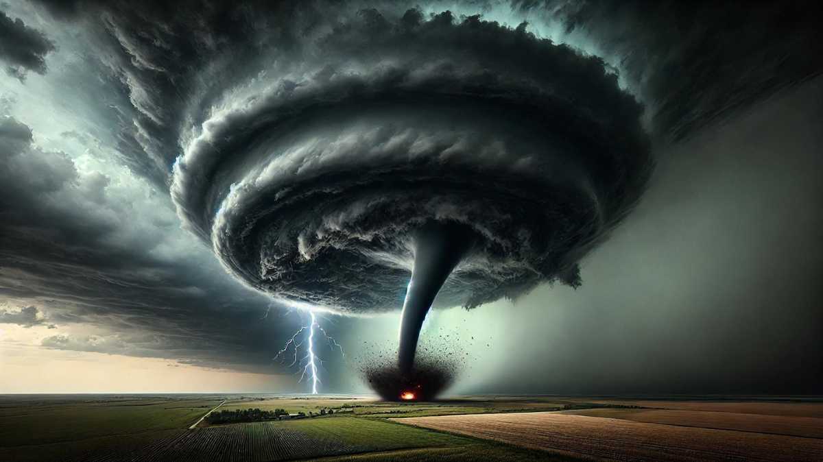
At the heart of any supercell tornado is its parent thunderstorm: the supercell. Picture a storm with a twist, literally! Supercells have a powerful rotating updraft, called a mesocyclone, that allows them to sustain themselves longer than your average storm. This rotation is driven by wind shear, where wind speed and direction change with height, creating the perfect recipe for extreme weather.
Why is this important? Because a supercell can last for hours, giving it plenty of time to unleash chaos like tornadoes, hail the size of baseballs, and fierce winds.
Anatomy of a Supercell
A supercell storm has some unmistakable characteristics:
- Rotating updraft (mesocyclone): This is the storm’s engine, driving all its severe features.
- Anvil-shaped cumulonimbus cloud: The classic “mushroom top” appearance marks the supercell in the sky, signaling trouble below.
- Persistent rotation: The storm’s ability to rotate for long periods increases its ability to spawn tornadoes.
How Do Supercell Tornadoes Form?
You may be wondering: “Do all supercells create tornadoes?” The answer is no, but most tornadoes that do form come from supercells. The formation process goes like this:
- Wind shear creates rotation in the lower atmosphere.
- This rotation is tilted upward by the storm’s strong updraft, forming a mesocyclone.
- If the rotation tightens and extends downward, voila—a tornado is born.
Supercell tornadoes can range from weak to absolutely monstrous. The most infamous tornadoes—like the ones that rip through entire towns—are usually supercell-born.
Why Are Supercell Tornadoes So Dangerous?
It’s not just the fact that these tornadoes can last longer than their non-supercell counterparts. Supercells can also produce stronger tornadoes, making them a double threat. The infamous EF4 and EF5 tornadoes, the highest ratings on the Enhanced Fujita Scale, typically spawn from these storms, with wind speeds reaching over 200 mph (322 km/h).
Additionally, supercells don’t just surprise with tornadoes; they come loaded with large hail, damaging straight-line winds, and in some cases, flooding. It’s like the ultimate storm cocktail—except no one’s ordering it.
Real-World Example
Remember the 2011 Joplin, Missouri Tornado? It was an EF5 tornado spawned by—you guessed it—a supercell thunderstorm. This tornado killed over 150 people, making it one of the deadliest in U.S. history. Supercells are no joke.
Types of Tornado-Producing Storms: Supercell vs. Non-Supercell Tornadoes
Not all tornadoes come from supercells. Let’s compare the differences between supercell and non-supercell tornadoes:
- Supercell Tornadoes: These are stronger, longer-lasting, and far more organized. They form within the rotating mesocyclone of a supercell.
- Non-Supercell Tornadoes: These tornadoes are usually weaker and form from processes unrelated to mesocyclones, such as landspouts or waterspouts.
While non-supercell tornadoes can still cause damage, they rarely match the ferocity of their supercell counterparts.
Supercell Tornadoes: Key Indicators to Watch For
If you’re ever caught in severe weather, recognizing the signs of a supercell storm can be life-saving. Here are the key indicators:
- Rotating clouds: Visible rotation at cloud base can be a warning that a tornado might form.
- Wall cloud: A lowering of the cloud base near the storm’s center often accompanies tornado formation.
- Funnel cloud: This is your last warning before a tornado officially touches down!
These visual cues, coupled with severe weather alerts, should signal that it’s time to seek shelter.
Can We Predict Supercell Tornadoes?
Thanks to advancements in meteorology, supercell tornadoes are now easier to predict than ever. Weather forecasters use tools like Doppler radar, which can detect the rotation of mesocyclones in storms. When forecasters spot this rotation, they issue tornado warnings to alert the public.
While we can’t perfectly predict every tornado, we’ve come a long way from the days of “tornado surprise.” Websites like the NOAA Storm Prediction Center and National Weather Service provide up-to-the-minute severe weather updates, making them essential tools in tracking tornado activity.
Conclusion: Why Supercell Tornadoes Are Nature’s Ultimate Show of Power
Supercell tornadoes represent the peak of Mother Nature’s power, combining longevity, strength, and unpredictability in one jaw-dropping package. While modern forecasting gives us the tools to track and prepare for these storms, their sheer force reminds us of our vulnerability to the natural world. Stay informed, be prepared, and always respect the storm when it comes knocking.
FAQs About Supercell Tornadoes
1. Can all supercells produce tornadoes?
Not all supercells spawn tornadoes, but most significant tornadoes come from supercells.
2. How long can supercell tornadoes last?
Supercell tornadoes can last from minutes to over an hour, depending on storm strength.
3. What’s the largest hail size reported from a supercell storm?
Hailstones as large as softballs (4.5 inches in diameter) have been recorded.
4. Are all EF5 tornadoes from supercells?
Yes, almost all EF5 tornadoes form from supercell thunderstorms.
5. How do Doppler radars detect supercell tornadoes?
Doppler radar identifies rotating updrafts (mesocyclones) within supercells, which can signal tornado formation.
Now you know all about supercell tornadoes—be prepared, stay safe, and don’t mess with Mother Nature’s most intense storms!
Author

An aspiring business leader, I am working towards my dream of graduating from Stanford University with a degree in Business Management. Passionate about sharing knowledge, I strive to empower others through education and collaborative learning.
View all posts